Author: ontheroa

  • San Carlos, Sonora: The Beach Town Beneath Tetakawi Hill

    San Carlos sits on the Sea of Cortez just outside Guaymas, in Sonora — one of our favourite overnight stops when we’re heading south on Mex 15.

    It started as a planned beach community, and today about 3,000 people call it home — a number that swells past 7,000 once the winter snowbirds roll in. The bays here are clear and shallow, which is why San Carlos has become such a draw for swimming, scuba diving, fishing, boating and sailing.

    Summers are hot and humid. Winters are the opposite — mild enough that RV parks, hotels and resorts fill up with Canadians and Americans escaping the cold.

    Watching over all of it is Tetakawi Hill, a jagged double peak the Yaqui called the “broken mountain.” Locals have their own, more colourful name for it in Spanish.

    San Carlos is just 5-6 hours — about 400 km — south of the Arizona border on Mex 15, which makes it a natural first-night stop if you’re driving into Mexico. We’ve stayed here more times than we can count.

    Watch the full 60-second reel above, and if you’re planning your own drive south, we’ve got guides to Mexican auto insurance, border crossings and road conditions right here on the site.

    Have you stopped in San Carlos on your way south? Tell us in the comments.

    Get a Mexico Auto & RV Insurance Quote →

  • Puerto Peñasco: The Beach Town Al Capone (Maybe) Built

    Puerto Peñasco: The Beach Town Al Capone (Maybe) Built

    Rocky Point sits at the north end of the Sea of Cortez, where the Sonoran Desert runs straight into the water – and depending who you ask, it’s either a quiet fishing town, a spring-break institution, or Arizona’s unofficial beach. All three are true at once.

    A Legend Built on Bootlegging

    Local legend has it that Al Capone built a casino, a water well, an airport, and a dock in Puerto Peñasco in the 1920s to help run his bootlegging operations across the border. It’s one of those stories that’s been repeated so often around town it’s practically civic history – except nobody has ever produced the paperwork to prove Capone was ever actually there. True or not, it fits: Prohibition-era America needed somewhere close, and Puerto Peñasco was about as close as it got.

    RV parked on the beach at Puerto Peñasco, photographed by Bill Bell

    From Fishing Camp to Arizona’s Beach

    Whatever kicked it off, the infrastructure boom that followed – roads, an airstrip, a working port – is what turned a fishing camp into a real town. Puerto Peñasco has been drawing Americans across the border ever since, helped along by a detail every Arizona teenager eventually learns: Mexico’s drinking age is 18, not 21. For decades that’s made it a favorite weekend and spring-break escape for visitors from Tucson and Phoenix, who are actually closer to this stretch of Mexican coast than they are to Hermosillo or Mexicali, the nearest Mexican cities in the other direction.

    The Point That Gave It Its Name

    Peñasco means “big rock” in Spanish, and the rocky point the town is built around is exactly that – a headland jutting into the Sea of Cortez that gave the place both its Mexican name and its English nickname, Rocky Point. Walk out to it and you get the whole town in one view: the malecón, the fishing fleet, and well over a hundred kilometers of beach running off in both directions.

    The rocky point and pier at Puerto Peñasco, photographed by Bill Bell

    The Video

    Photography by Bill Bell. Produced by Dorothy Bell.

    Planning to drive down yourself? We’ve laid out the logistics – the border crossing, what permit you actually need for a Sonora-only trip (and the one you don’t), and where to stay – over on our sister site: Visiting Puerto Peñasco: The Logistics.

    Bootlegger’s legend aside, is it the beach, the history, or the drinking age that keeps pulling people back to Rocky Point?

  • Mexico Weekly News Highlights: September 13–19, 2026

    Week of September 13–19, 2026

    Independence celebrations, trade negotiations and practical travel developments shaped the week in Mexico. Here are eight stories to catch up on, with brief summaries and direct links to the original reporting.

    Independence celebrations put sovereignty and community in the spotlight

    September 15–16

    President Claudia Sheinbaum led the Grito de Independencia from the National Palace as Mexico marked 216 years since the beginning of its independence movement. Her address recognised Indigenous and Afro-Mexican communities and Mexicans living abroad, alongside a renewed emphasis on national sovereignty.

    Read the report: El País (Spanish)

    Mexico–U.S. trade talks advance, but no final agreement is announced

    September 18

    Sheinbaum said negotiations with the United States were progressing following another call with President Donald Trump. She stressed that a final agreement had not yet been reached. The discussions come ahead of further trade negotiations involving tariffs on Mexican vehicles, steel and aluminium.

    Read the report: El País (Spanish)

    The peso ends the week weaker against the U.S. dollar

    September 18

    The peso finished Friday at approximately 17.23 per U.S. dollar, according to El Economista, recording a weekly decline of 1.55%. For travellers budgeting in dollars, the figure offers a snapshot of the market—not the rate a bank, ATM or exchange counter will necessarily provide.

    Read the report: El Economista (Spanish)

    Mexico prepares for its September 19 earthquake drill

    Reported September 17; scheduled for September 19

    Mexico’s second national emergency drill of 2026 is scheduled for noon, Mexico City time, on September 19. The exercise includes regional earthquake scenarios and alerts through loudspeakers and compatible mobile phones. Visitors should ask their accommodation about its evacuation procedure and designated meeting point.

    Read the report: El País (Spanish)

    Education authorities announce plans to restrict phones in schools

    September 19

    Mexico’s education authorities reached an agreement to restrict cellphone use throughout the school day in primary and secondary schools, with implementation planned for October. La Jornada reported that the full document had not yet been published. Upper-secondary and higher-education communities would develop their own rules.

    Read the report: La Jornada (Spanish)

    Culiacán residents march for peace

    September 13

    Residents marched in Culiacán, Sinaloa, calling for an end to violence and justice for missing relatives. Reuters footage showed families carrying photographs and banners after a mass. Their appeals placed the impact on children, parents and everyday community life at the centre of the demonstration.

    Read the report: Reuters video report (English description; Spanish interviews)

    Border-wall construction begins in part of Texas’s Big Bend region

    September 18

    U.S. authorities began installing border-wall panels in Hudspeth County, according to the Associated Press. The work has faced opposition from landowners and environmental groups. AP distinguished this project from construction inside nearby Big Bend National Park, which had been temporarily suspended.

    Read the report: Associated Press (English)

    Road reports underline the need to check conditions before departure

    September 18

    N+ reported accident-related closures on the México–Querétaro highway and Querétaro’s northeastern bypass, alongside disruptions elsewhere. These were time-specific reports, not a list of continuing closures. Before a driving day, check fresh notices for your exact road, direction and departure time.

    Read the report: N+ (Spanish)

    Prepared on the morning of September 19, 2026. This roundup covers reports published September 13–19. Scheduled events and developing stories may change; source links include English and Spanish coverage.
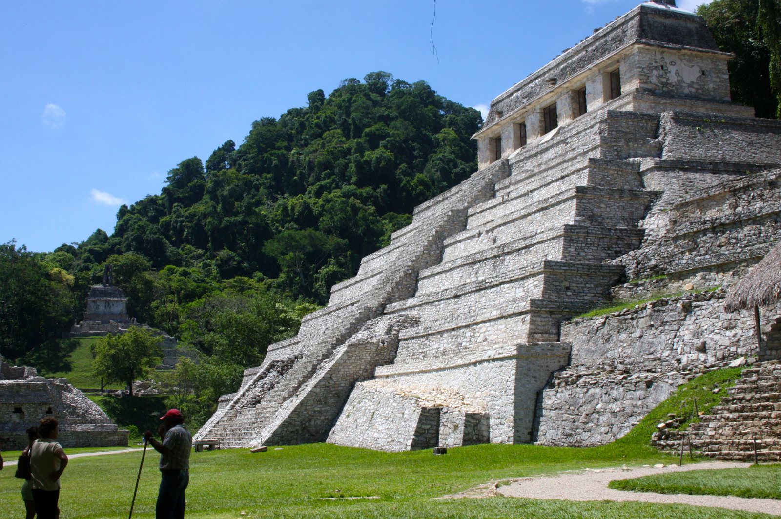
  • Palenque: The Jungle City of the King Who Ruled 68 Years

    Palenque: The Jungle City of the King Who Ruled 68 Years

    Most Maya sites make you imagine the jungle that used to surround them. At Palenque, you don’t have to imagine it – it’s still there, closing in right at the edge of the plazas, with the calls of howler monkeys carrying over the ruins most mornings.

    A King Crowned at Twelve

    Palenque’s story is really the story of one man: K’inich Janaab’ Pakal, who took the throne at age twelve after the city had been badly beaten down by its rival Calakmul, and then ruled for 68 years. Nearly everything visitors see today – the Palace, the temples, the astronomical alignments built into the architecture – dates from his reign or his son’s. He didn’t just rebuild a defeated city. He turned it into one that, by the accounts left behind, eclipsed even Tikal.

    What Was Found Inside the Temple of Inscriptions

    Pakal’s funerary temple is the site’s centerpiece, and for a good reason: in 1952, archaeologist Alberto Ruz Lhuillier climbed down a hidden staircase sealed for over a thousand years and found Pakal’s tomb waiting exactly as it had been left – jade mask, jade jewelry, and a carved sarcophagus lid whose imagery has been endlessly (and wrongly, per mainstream archaeology) reinterpreted online as depicting an astronaut. It isn’t. It’s a king falling into the underworld to be reborn, straight out of Maya cosmology. It’s still one of the richest royal burials ever found anywhere in the Americas.

    Why It Went Quiet

    By around 799 AD, Palenque was abandoned, part of the broader collapse that hit Maya cities across the region. The jungle did the rest, swallowing the site so completely that Spanish explorers who stumbled onto it in the 1520s barely registered what they’d found. Serious excavation didn’t start until 1773, and the tomb itself sat undiscovered for another 180 years after that.

    The Video

    Photography by Bill Bell. Produced by Dorothy Bell.

    Planning to drive there yourself? We’ve laid out the logistics – the drive in, hours and admission, and the Highway 199 safety note – over on our sister site: Visiting Palenque: The Logistics.

    Between the setting and the history, Palenque tends to hit people differently than the more open sites like Chichén Itzá or Uxmal. What was your reaction the first time you stood in front of it?

  • Uxmal: The Maya City the Dwarf King Built in a Single Night

    The tallest thing at Uxmal isn’t shaped like any other pyramid in the Yucatán. Instead of straight sides and square corners, the Pyramid of the Magician rises out of an oval base, steep and rounded, like something poured rather than built. The Maya who lived here clearly meant it to stand apart, and centuries later, it still does.

    Five Temples, One Pyramid

    What you’re looking at isn’t one building — it’s five. The Maya practice of superimposition means each generation built a new temple over the last rather than tearing anything down, and archaeologists have traced five distinct construction phases packed inside this single structure. The oldest, at the base, dates to the 6th century and carries the hook-nosed masks of Chaac, the rain god, in the blocky Chenes style. The newest, capping the whole thing, went up around the 9th century in the more refined Puuc style Uxmal is famous for. Four hundred years of building, one pyramid.

    The Legend

    Ask locally how it got built, and you won’t hear about labor gangs or centuries of construction — you’ll hear about a dwarf. The story goes that a witch hatched him from an egg, and when the ruling king challenged him to build a pyramid overnight or be put to death, he did exactly that, and became king himself by morning. It’s a folk tale, not a historical record, but it’s told for a reason: nothing about this building looks like it happened at a normal, human pace. The five-temples-in-one truth is almost stranger than the myth.

    A City, Not Just a Pyramid

    Uxmal held something like 25,000 people at its peak between 600 and 1000 AD, and the Pyramid of the Magician is only the introduction. The Governor’s Palace and the Nunnery Quadrangle — a name the Spanish gave it, not the Maya — carry some of the finest stone mosaic work anywhere in the Maya world, latticework and geometric patterning cut directly into the facades rather than painted on. UNESCO named the whole site a World Heritage location in 1996, and it earns it.

    The Video

    Photography by Bill Bell. Produced by Dorothy Bell.

    Planning to drive there yourself? We’ve laid out the logistics — the drive from Mérida, hours, admission, what to know before you go — over on our sister site: Visiting Uxmal: The Logistics.

    If you’ve climbed the Puuc route and stood in front of this one, what struck you — the scale, or the strangeness of the shape?

  • Santo Domingo de Guzmán: Oaxaca’s Golden Baroque Church

    In the heart of Oaxaca City, behind a stone facade the color of old bone, is one of the most extravagant church interiors anywhere in the Americas. We’ve walked through it more than once over the years, and it still stops us every time.

    The Templo de Santo Domingo de Guzmán was started by Dominican friars in 1572. It took the better part of four decades before it was formally dedicated in 1608 — and even then, the building wasn’t finished. Its richest addition, the Rosario Chapel, wasn’t begun until 1724, more than 150 years after the first stone went in.

    It Wasn’t Always a Church

    The building’s history isn’t a straight line from construction to congregation. Through much of the 1800s, during Mexico’s wars and internal conflicts, the complex was occupied by whichever faction controlled Oaxaca at the time. By 1859 it had been formally converted to military use, and by 1866 Catholic worship here was suspended altogether. It wasn’t returned to the Church until 1902, under President Porfirio Díaz, and restoration took decades after that.

    Walking In

    None of that turmoil shows on the inside. Step through the doors and the nave is covered almost floor to ceiling in gold leaf — walls, arches, the vaulted ceiling, the retablo behind the altar. It’s Baroque decoration taken about as far as it can go, and photographs genuinely undersell it. The side chapels get the same treatment: gilded canopies, carved saints in niches, centuries of devotion layered on in gold leaf.

    Outside, the twin bell towers and tiled domes form one of the most photographed skylines in Oaxaca. The plaza in front draws street painters working the same view over and over, along with tourists and locals just cutting through on their way somewhere else.

    Visiting

    It’s free to enter, no ticket required. The adjoining former convent now houses the Regional Museum of Oaxaca, worth an hour on its own, and the old monastery garden behind it has been replanted as an ethnobotanical garden. Dress reasonably modestly if you’re going inside — it’s a working church, not a museum piece.

    Getting There

    Oaxaca City sits inland in the southern highlands. Coming from Mexico City, it’s a 5 to 6 hour drive on the toll autopista through Puebla. Coming up from the coast at Huatulco, you’ve got a choice: a newer toll road that cuts the trip down considerably, or the old Highway 175 through the mountains — slower, winding, and genuinely beautiful, with mountain towns like San José del Pacífico worth a coffee stop along the way. Either way, once you’re in the historic center, Santo Domingo is a walk, not a drive.

    The Video

    Photography by Bill Bell:

    Four and a half centuries of construction, war, secularization, and restoration, and what’s left standing is one of the most over-the-top church interiors you’ll find anywhere in Mexico. If you’ve stood inside it yourself, we’d love to hear what struck you most.

  • Scammon’s Lagoon: Where Gray Whales Come to Raise Their Young

    There’s a stretch of Baja California coastline where, every winter, a few thousand gray whales show up to do exactly what their ancestors have done for generations: mate, give birth, and nurse their calves in water calm and warm enough to give a newborn whale a fighting chance before the long swim north to Alaska.

    It’s called Scammon’s Lagoon by English speakers and Laguna Ojo de Liebre by Mexicans, and it sits on the Pacific side of the peninsula near the town of Guerrero Negro — roughly 8 to 11 hours’ drive south of the border, depending on where you cross.

    The name itself is a bit of an uncomfortable history lesson. Charles Melville Scammon was an American whaling captain who found the lagoon in 1857, and within a few short years he and the other whalers who followed him had hunted the gray whale population here to the edge of extinction. It’s a strange thing, watching whales in a place named after the man who very nearly wiped them out. But the whales came back, the lagoon became a protected biosphere reserve, and today it’s one of the best places on Earth to watch gray whales up close, in the water they were once hunted in.

    Thousands of Whales, a Few Feet Away

    From January through March, thousands of gray whales migrate into the lagoon. At the peak of the season there can be as many as 1,000 whales here at once. Visitors go out in small boats called pangas — open skiffs that hold 8 to 12 passengers — and it doesn’t take long before you understand why people fly and drive a very long way to do this.

    Some of the whales here are known as “friendlies.” Nobody’s entirely sure why, but certain whales — often mothers with calves — will approach a panga on their own, sometimes close enough for someone to reach out and touch them, or for a whale to lift its head almost close enough to kiss. It’s not staged, and it’s not guaranteed, but it happens often enough that it’s become part of the lagoon’s reputation.

    And then there’s the breaching. Whale after whale hurling itself out of the water, reaching for the sky, and sinking slowly back into the lagoon — over and over, all around the boat. It’s the kind of thing photographs never quite do justice to, which is why we put together a short video from some of Dorothy’s photos rather than just describing it.

    Getting There, and Getting on the Water

    Scammon’s Lagoon is an easy add-on to a Baja road trip. Guerrero Negro sits right on Highway 1, so if you’re already driving the peninsula, you’re not going far out of your way. Boat trips run out of town, and most hotels in the area can arrange a spot for you — no advance booking from home required, though showing up during peak season without a plan is asking for a disappointing morning.

    If you’re driving down from the US or Canada, remember that Mexican law requires Mexican auto insurance — your home policy won’t cover you south of the border, no matter what your provider tells you. We’ve spent more than three decades driving every state in Mexico, and getting proper coverage sorted before you leave is one of those small pieces of preparation that saves you a world of trouble later. We put together what we’ve learned about Mexican auto and RV insurance for US and Canadian vehicles if you want the details before you go.

    The Video

    Produced by Bill and Dorothy Bell, photography by Dorothy Bell:

    Whale watching seasons vary a little year to year, but January through March is the reliable window. If you’ve been to Scammon’s Lagoon yourself, or you’re planning a trip, we’d love to hear about it in the comments.

  • Sunrise Balloons Over Teotihuacán: A Bucket-List Morning

    Dorothy and I have been driving around Mexico for more than 35 years, and there are certain sights that still stop us in our tracks no matter how many times we’ve seen them. A sky full of hot air balloons drifting silently over the Pyramid of the Sun and the Pyramid of the Moon at sunrise is one of them. It’s one of those experiences that photographs don’t quite do justice to — you really do have to stand there and watch it happen.

    Getting there

    Teotihuacán is an easy one-hour drive from Mexico City, which makes it one of the most accessible bucket-list experiences anywhere in the country. You don’t need to plan an expedition — just an early alarm.

    Booking your flight

    Balloon flights over Teotihuacán are bookable right through your hotel — no need to hunt down a separate tour operator once you’re there. Ask when you check in, or arrange it a day or two ahead if you want to be sure of a spot.

    What the morning looks like

    Pick-up is early, well before sunrise. You’re driven out to Globoport, the balloon launch site near the pyramids, where the balloons are already being laid out and inflated. Once they’re up, crews escort each group of travellers to their designated balloon — there are usually several balloons launching together, which is part of what makes the sight so spectacular once you’re airborne and can see the others drifting alongside you.

    Music plays throughout the whole experience, from the drive out to the moment you’re hovering over the ancient city itself, watching the sun come up over pyramids that have stood there for close to two thousand years.

    One small piece of advice: take your phone up with you, and call someone you love while you’re airborne. Let them share the moment with you in real time. It’s the kind of experience that’s better when someone else gets to hear you react to it.

    Watch it before you go

    We put together a short video from photos taken on flights over the pyramids — balloons inflating in the pre-dawn light, the burners firing, and that unforgettable view once you’re up over the ancient city.

    One thing to sort out before you leave

    However you’re getting to Teotihuacán — as a day trip from Mexico City or as part of a longer Mexico road trip — make sure your Mexican auto insurance is arranged before you go. Canadian and U.S. policies generally do not satisfy Mexico’s liability requirements, so this is something we prefer to sort out before reaching the border.

    See our Mexico auto insurance guide and compare coverage options here.

    We may receive a commission if you purchase through our insurance links, at no additional cost to you.

    Put Teotihuacán by balloon on your Mexico bucket list. It’s an easy add from Mexico City, and it’s the kind of morning that’s hard to describe properly until you’ve floated over it yourself.

    Drive Mexico – Best Travels
    Photography by Bill Bell

  • Flamingos, Flamingos Everywhere: A Day Trip to Celestún

    Dorothy and I have been driving around Mexico for more than 35 years now, and every so often we still find something that stops us cold. Celestún did that to us. You come around a bend in the mangroves expecting maybe a few dozen birds, and instead the water is pink from one side of the horizon to the other. At peak times there can be close to 35,000 flamingos in the Celestún Biosphere Reserve. That’s not a typo.

    The good news is you don’t need an expedition to see it. This is one of the easiest, most rewarding day trips you can make from Mérida.

    Getting there

    It’s about a 90-minute drive west of Mérida on Highway 281, and the drive itself is part of the reward — you pass through small, authentic Yucatán communities the whole way, the kind of towns where turkeys still have the right of way on the main street. When you come into Celestún, cross the bridge and look for the Parador Turístico on your left. That’s the tourist cooperative pier, and it’s the best place to arrange your boat into the reserve — legitimate, well-organized, and the boat captains know exactly where the birds will be that day.

    Budget roughly $100–160 USD per boat, which holds 6 to 8 people, for a trip that runs 90 minutes to two hours. Split among a group, it’s genuinely inexpensive for what you get.

    When to go

    Best viewing is November through February, when the flamingo numbers are at their peak. You’ll still see birds outside that window, but if you want the sky-and-water-both-pink experience, plan around those months.

    Watch it before you go

    We put together a short video from photos we’ve taken there over the years — the drive in, the pier, the boats, and the flamingos themselves, lifting off in that late-afternoon light that Yucatán does so well.

    One thing to sort out before you leave

    However you’re getting to Celestún — whether this is a side trip from a longer Yucatán road trip or you’re driving down from the border — make sure your Mexican auto insurance is arranged before you go. Canadian and U.S. policies generally do not satisfy Mexico’s liability requirements, so this is something we prefer to sort out before reaching the border.

    See our Mexico auto insurance guide and compare coverage options here.

    We may receive a commission if you purchase through our insurance links, at no additional cost to you.

    Put Celestún on your Mexico road-trip list. It’s an easy add if you’re already anywhere near Mérida, and it’s the kind of thing that’s hard to describe properly until you’ve seen it yourself.

    Drive Mexico – Best Travels
    Photography by Bill Bell

  • Driving an RV in Guanajuato: The Tunnel That Took Our Awning

    Driving an RV in Guanajuato produced one of those Mexico road stories we have never forgotten. A wrong turn sent our 28-foot Class C motorhome into the city’s underground streets, where a narrow tunnel collected a souvenir from the side of our rig: the awning.

    We were staying at an RV park outside Guanajuato and decided to drive into the city. This was back in the days of paper maps. There was no friendly voice from a phone warning us that we had missed a turn or offering to recalculate the route.

    Through happenstance—and probably one unfortunate turn—we found ourselves travelling down a one-way road leading directly into one of Guanajuato’s tunnels.

    There was no retorno and nowhere to turn around. Once we entered, we were committed.

    Read the complete story, see Bill Bell’s photographs and find practical advice for RV drivers on On the Road in Mexico.