October 4–9, 2026 | By Bill Bell
Published October 9, 2026. Weather snapshot: 0900 UTC.
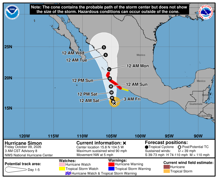
This week’s main concern is Hurricane Simon and its forecast effects along Mexico’s Pacific coast. Below are the weather advisories verified early Friday, dated road developments, and recent journeys shared in our On the Road in Mexico Facebook group. Conditions can change after a traveller passes through; check your route again before departure.
Pacific coast: Simon brings a serious weather threat
At 3 a.m. CST on October 9, NHC Advisory 8 reported Simon’s sustained winds at 90 mph (150 km/h). A hurricane warning covered Punta San Telmo to Punta Mita, with a tropical-storm watch eastward to Lázaro Cárdenas. Heavy rain, flooding and landslides threaten Michoacán, Colima, Jalisco and Nayarit through Sunday. These were the latest Simon details verified; check the dated NHC advisory and current NHC updates.

Our travel advice: postpone nonessential coastal journeys through the warning area. Do not assume an inland mountain detour is clear of flooding or landslides. This forecast does not establish a specific highway closure.
Baja California: check Rachel separately
Rachel is a separate concern. The 2 a.m. PDT October 9 advisory forecast weekend rain across parts of Baja and an increasing wind risk in the north. No coastal watches or warnings were then in effect. Check fresh forecasts before using northern Baja’s border approaches and coastal roads.
Sonora and Sinaloa: traveller observations and a dated reopening
One RV party described crossing at Nogales–Mariposa on Tuesday and reaching Isla de la Piedra, south of Mazatlán, on Wednesday, with an overnight stop in Navojoa. They reported poor pavement from Santa Ana toward a point they described as around km 83 (the marker reference is unconfirmed), as well as from Guasave through the Culiacán bypasses and in the hills north of Mazatlán. They also noted a military presence near Mazatlán. These are pavement observations from one journey, not a statement that the route is clear today. Member’s report (group access required).
Guasave, México 15: southbound traffic between Guayparime and El Burrión reopened after 6 p.m. on October 8 following the transfer of diesel from an overturned tanker. Initial traffic was slow. This is a dated reopening, not a guarantee of today’s conditions. Línea Directa’s report quotes municipal Civil Protection.
Texas crossings: Piedras Negras–Durango and McAllen–Chapala
A member travelling from Texas to Durango via Piedras Negras Bridge II reported a short flood-related road diversion near the bridge, wildlife along the Coahuila stretch, and a noticeable police and military presence. A separate October 3 local report documented rain damage and an approximately 300-metre restriction on the Fausto Z Martínez approach. Its October 9 status remains unconfirmed: follow posted diversions and check the approach before crossing. Member’s report (group access required).
Another member described a recent, uneventful 13-hour McAllen–Chapala drive, with substantial police and National Guard presence. The route they gave was 101–57D–80D; that is their reported route, not our routing recommendation. They described a courteous National Guard inspection south of San Luis Potosí lasting less than five minutes. Member’s report (group access required).
Puebla and Tijuana: local access works
San Martín Texmelucan: works were scheduled to close the local connection toward the Puebla-bound México–Puebla motorway from October 7 through October 10. This concerns the access connection, not the entire motorway. El Popular reports the municipal notice.
Tijuana: the El Mirador access ramp in the Playas de Tijuana-to-Zona Centro direction was scheduled to close October 5–15 for sinkhole repairs. This is a local-access restriction, not confirmation of a Highway 1 or 1D closure. N+ roadworks report.
Before you leave—and how to contribute
The three Facebook journeys above were reviewed October 9; exact calendar travel dates were not confirmed. They describe individual trips, not current clearance of an entire route. For roads operated by CAPUFE, call 074 for information and assistance; other roads have different operators. CAPUFE contact information.
Have you driven a Mexican route this week? Add your report to On the Road in Mexico with the travel date, road number, direction, nearest town or kilometre marker, and time. Tell us what you personally saw, including whether traffic was moving again after a delay. Dated details help the next driver.
Leave a Reply